Article by Tony Roberts, first published in The Archer, April 1997.
The development of present-day East Finchley owes much to the far-off era of the Anglian Ice Age which has left us a fascinating legacy.
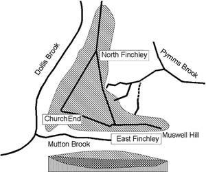
The reason why some gardeners in N2 break backs and garden tools in the effort to find some semblance of soil amongst the heavy clay, while others delight in softer, manageable earth is best explained by the British Geological Survey Map. Opening the map your attention is caught by a triangle, the Finchley triangle, sitting in the midst of the surrounding brown clay. Fortis Green, East End Road and Ballards Lane run along southern and north western sides of this triangle at a fairly regular height of 90 – 95 metres but the triangle dips down toward the north east, to where the High Roads of East and North Finchley meet the North Circular Road.
The triangle covers a unique surface layer of chalky, sandy clay, pushed down from the north and deposited when the icecap melted. Under this clay, in a hollow in the base clay of the region, lies a “filling” of Dollis Hill gravel, probably deposited by a major tributary flowing north to join the Thames, then flowing through Watford. The ice cap blocked these northern routes, forming enormous lakes, and diverted the Thames through London on its current course.
The gravel “filling” has acted as a reservoir ever since, excess rain water flowing over the join between gravel and clay in numerous streams, noticeably to the north east, to join Pymm’s Brook and the River Lea. The steep southern and north western sides drain westward, the Dollis Brook and Mutton Brook joining to form the Brent Brook which flows backward along the earlier river course.
The topography of this triangle has played a key part in the history and development of East Finchley.
Reproduced by kind permission East Finchley Newspapers CIC
Acknowledgements: British Geological Survey, London & The Thames Valley, 1996 edition


